Altamaha River Flathead Project: More than One Way to Skin a Cat: Controlling the spread of invasive flathead catfish through research, outreach and education
| Project Start Date | |
|---|---|
| Project Leader | |
| Organization |
The Altamaha River Watershed Conservation Action Plan cites invasive species as one of the six highest ranked threats. One of the invasive species thriving in portions of the watershed is the flathead catfish, which cause environmental harm, threaten native species, and can change the recreational value of an area for anglers. User groups (general public, children, anglers, commercial fishermen) as well as watershed managers must work together to control a population by size or area of infestation.
Partner(s): Georgia Department of Natural Resources National Marine Fisheries Service
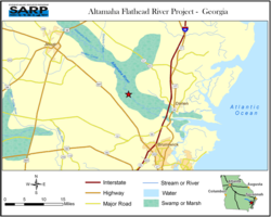
- Altamaha Flathead River Project - Georgia
Description of Site:
-
Although work occurs along the lower reaches of the Altamaha, it centers around Altamaha Regional Park.
Problem:
- The flathead catfish is popular with some groups of anglers and commercial fishermen.
-
Flathead catfish preys on native sunfish, also popular with anglers. Sunfish are larval hosts for many of the rare freshwater mussels dwelling in the Altamaha.
Strategy:
- Educate user groups by involving them in
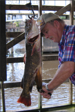
- Fishers participate in gut analysis on site.
- Increase communication among user groups and help them become proactive controllers of ANS.
- Study the reasoning and values of the user groups to better understand how to secure their ongoing help in controlling ANS that are both invasive and popular.
This project is not completed. Educational activities appear to be bearing positive fruit. About 50% of the data collection has been completed.
Contact Info
- Lisa Liguori
- GA
- Email: liguori@uga.edu
Related Resources & Documents
Associated Locations
| Town | zip code | county | state | congressional dist |
|---|
Barriers
| Name of barrier | Latitude | Longitude | FONS ID | FIS Project ID | FWS Acc. # |
|---|
Document Actions
